Research
My research interests are centered around Earth and planetary surfaces processes and the preservation and reflection of these processes in the topographic and stratigraphic record. To date, the bulk of my research has focused on fluvial landscapes, and more specifically on meandering river processes, topography, and stratigraphic architecture. I am also interested in developing and implementing Python workflows for analysis and visualization of geospatial data (e.g., 3-D point clouds, digital elevation models, multi/hyperspectral imagery), and I am starting to explore image segmentation and classification approaches using convolutional neural networks for automated landform detection. My current and past research locations, as well as brief summaries of my current projects, can be found below.
Publications
The impact of post-cutoff bend curvature on channel kinematics in meandering rivers: An example from the Trinity River, Texas, USA
(2023) Geological Society of London, Special Publications, v. 540.Journal Article (OA)
Seismic expression and stratigraphic preservation of a coastal plain fluvial channel belt and floodplain channels on the Gulf of Mexico inner continental shelf
(2022) Sedimentology, v. 70, pp. 451-474Journal Article
MORPHOLOGIC, TOPOGRAPHIC, AND STRATIGRAPHIC EVOLUTION OF MODERN FLUVIAL LANDSCAPES
Meandering rivers are among the most dynamic geomorphic features are Earth. Independently, we know quite a bit about how and why rivers 'meander' and - very generally - the types of deposits that meandering rivers leave behind as they evolve. However, we still have quite a bit of work to do in developing quantitative linkages between specific geomorphic processes and the subsequent behavior and depositional architecture in these highly dynamic environments. Establishing these linkages will enhance our interpretations of past planetary surface processes ,configurations, and conditions.
This project focuses on the process of meander bend cutoff (above right), subsequent bend change, and the topographic and stratigraphic evolution that results. Bend cutoffs are essentially perturbations to the meandering process that affect the in-channel morphodynamics and spatial migration rates of adjacent meander bends. This work quantifies the relationship between cutoff geometry and the subsequent effect on migration rates, as well as the depositional/erosional patterns that result. Find more about this at the links provided below.
PRESERVATION OF FLUVIAL LANDSCAPES IN THE ANCIENT STRATIGRAPHIC RECORD
Meandering rivers are highly dynamic, and they are capable of eroding and reworking their deposits over very short timescales. Therefore, it is likely that much of the ancient rock record in meandering river deposits is 'missing'. However, to this point it is difficult to say much more than that, because outcrops rarely have the spatial context necessary and seismic data rarely have the vertical resolution required to make these interpretations. There are several locations on Earth (and on Mars) that offer very well-preserved and regionally extensive outcrops of fluvial stratigraphy, and which may be used to quantify stratigraphic preservation in these highly-dynamic environments. See Zaki et al. (2020) for a comprehensive list of these locations, if this is of interest to you!
In this project, I study one such example in the Cedar Mountain Formation, Central-Eastern Utah, USA. The exposures in this portion of the Cedar Mountain have made it of great interest to fluvial stratigraphers and geomorphologists. This study focuses on a very specific portion (above right) that we hypothesize to represent the site of a river avulsion that occured during the Early Cretaceous - one of the few recognized in the ancient rock record. We use a combination of 3-D digital outcrop models, lidar-derived digital terrain models, and field data to quantify linkages between the avulsion processes and the preserved stratigraphic remnants left behind, which has implications for more informed interpretations of the ancient rock record on Earth and other planetary surfaces.
AUTOMATED IDENTIFICATION OF DUNE FIELDS ON MARS USING DEEP LEARNING
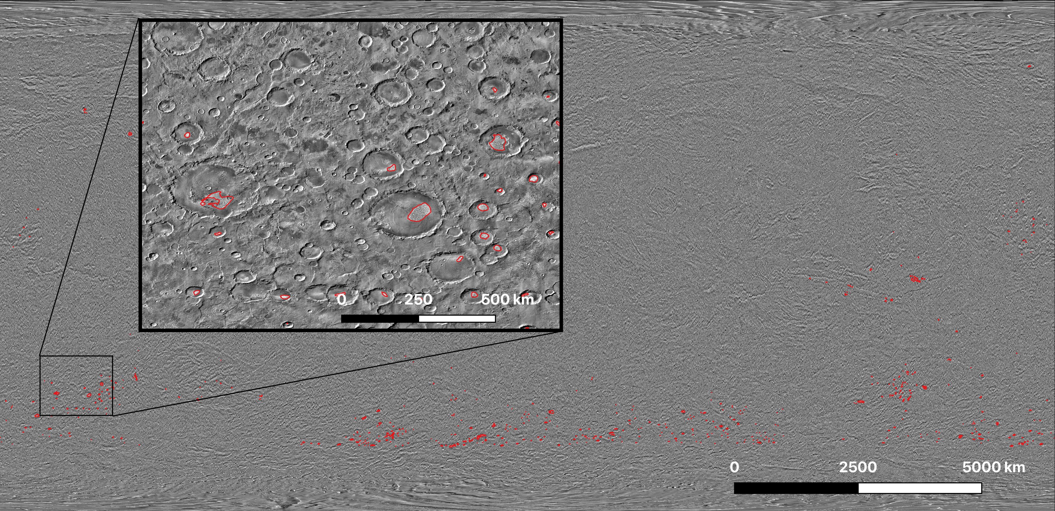
Deep learning has seen rapid advancement and implementation across a broad range of scientific disciplines, including the fields of computer vision and medical imaging. More recently, deep learning approaches have seen application in planetary science as a tool to leverage the growing wealth of surface imagery made available by planetary orbiters. To-date, much of the mapping and investigation of Earth and other planetary surfaces has been done 'by hand' through manual identification and digitization of features based on their visible or spectral character in satellite images. Deep learning applied to image segmentation and classification has shown promise in automated geologic landform detection, with the key advantage that it can be performed relatively rapidly over large spatial (even global) extents on personal workstations or cloud-based CPU/GPUs.
Recently, a colleague in The Oden Institute for Computational Engineering and Sciences at UT-Austin, Yiran Shen, and I have started to explore how deep learning approaches could be applied to automatically detect landforms on the surface of Mars and other planets using visible and thermal satellite imagery. We have approached this problem through the use of a convolutional neural network (CNN) and have developed and tested a workflow for the identification of aeolian dune fields across much of the surface of Mars. We chose to develop this method based on dune fields because of their unique appearance in satellite images, as well as their widespread distribution across the Martian surface. Importantly, it is likely that many of the dune fields on Mars remain unmapped (at least at the time of this work). Luckily, the very hard work of manually mapping dune fields for model training had been done for us, at least in part, by the creators of the Mars Global Digital Dune Database (MGD3). We trained, validated, and tested our model in the Jupyter notebook linked below and are encouraged by these initial results.